FAA Identifier: KXNX
Latitude/Longitude:
36-22-36.641N/086-24-31.531W
36-22.61068N/086-24.52552 W
36.3768447 /-86.4087586(estimated)

Elevation: 584 ft. / 178.0 m (surveyed)
Variation: 02W (1995)
From city: 2 miles east of Gallatin, Tennessee.

Pilot Information
Communications:
Service Frequency / Telephone
CTAF: 123.05
UNICOM: 123.05
WX AWOS-3: 132.725 615-230-8005
Ground Communication Outlet (GCO) 135.075(4 long clicks)
NASHVILLE APPROACH:
118.40
NASHVILLE DEPARTURE:
118.40
WX-AWOS at Lebanon: M54 (12 nm S): 118.325 615-444-5778
WX-AWOS at Portland: 1M5 (13 nm N): 118.175 615-325-4971
WX ASOS at Nashville: BNA (20nm SW): 615-360-6133
Inspection:
Inspected by:
State of Tennessee aeronautical personnel
Last inspection:
April 2017
Federal agreements:
National Plan of Integrated Airport Systems (NPIAS)
Grant agreements under FAAP/ADAP/AIP
Assurances pursuant to Title VI, Civil Rights Act of 1964
Statistics:
Aircraft based on the field: 90
Single engine airplanes:75
Multi engine airplanes:9
Jet airplanes: 5
Helicopters: 1
Aircraft Operations: 90/day
Local general aviation: 74%
Transient general aviation: 22%
Air taxi:4%
Military:<1%
Runways:
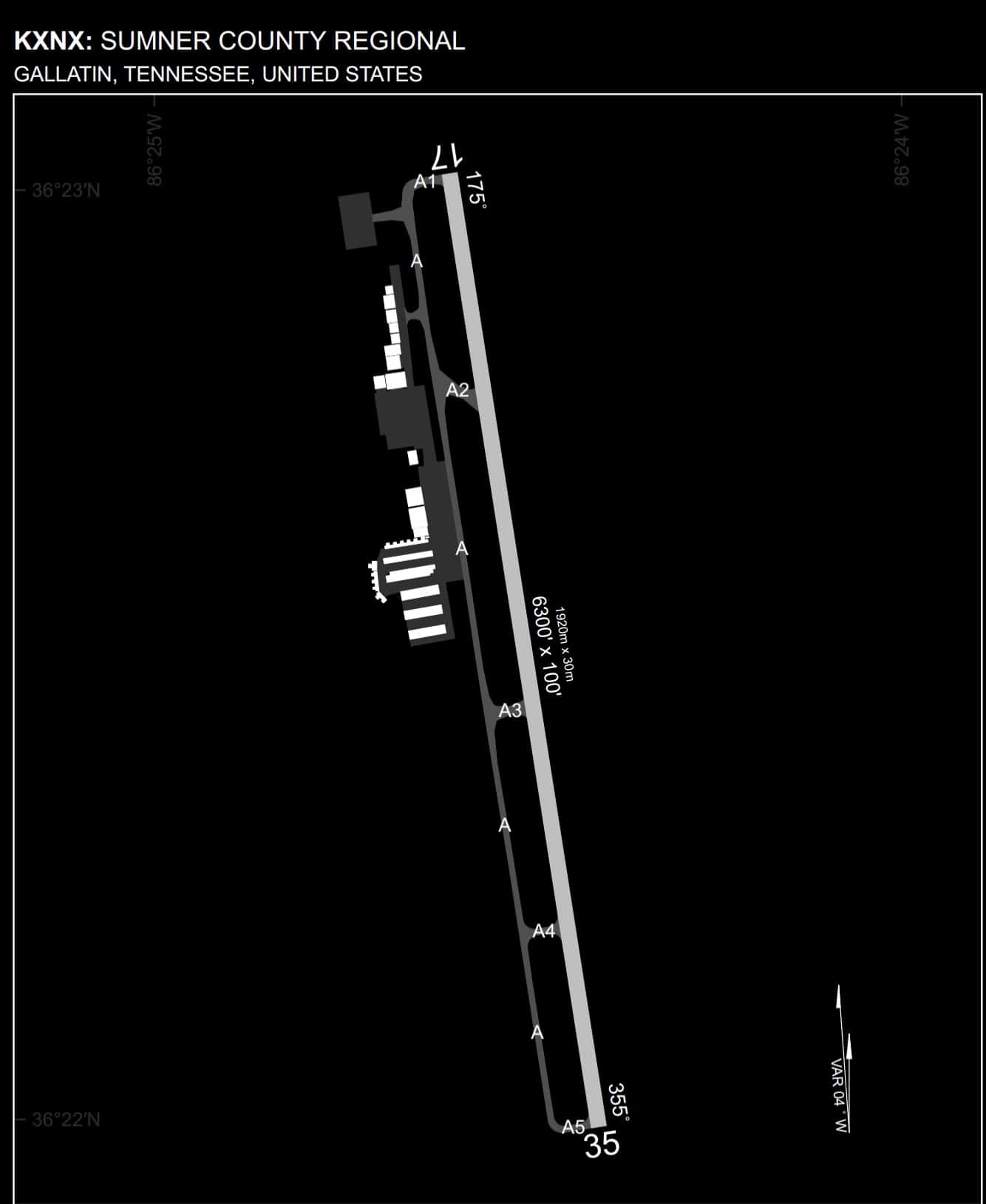
Runway 17/35
* Dimensions: 6300 x 100 ft. / 1524 x 30 m
* Surface: asphalt, excellent condition
* Weight limitations: Single wheel: 45000 lbs
* Double wheel: 96000 lbs
* Runway edge lights: low intensity (3 x mic clicks), medium intensity (5 x mic clicks), high intensity (7 x mic clicks)
* Runway edge markings: Excellent condition.
Runway 17
* Traffic pattern: left
* Runway heading: 173 magnetic, 171 true
* Markings: Excellent condition
* Latitude: 36-23.01767N
* Longitude: 086-24.60475W
* Elevation: 583.7 ft.
* Visual slope indicator: 4-light PAPI on left
* Runway end identifier lights: yes
* Touchdown Point: yes, no lights
* Obstructions: 71 foot tree, 870 feet from runway,
* 278 ft. right of centerline,
* 9:1 slope to clear
Runway 35
* Traffic pattern: left
* Runway heading: 353 magnetic, 351 true
* Markings: Excellent condition
* Latitude: 36-22.20368N
* Longitude: 086-24.44627W
* Elevation: 542.2 ft.
* Visual slope indicator: 4-light PAPI on left
* Runway end identifier lights: yes
* Touchdown Point: yes, no lights
* Obstructions: 59 ft. trees, 1020 ft. from runway,
* 344 ft. right of centerline,
* 13:1 slope to clear